Weather forecasters called it days ago, but the sheer speed of Typhoon Bavi still caught parts of East Asia completely flat-footed. We often watch these massive storm systems on radar, tracking their predictable paths toward major coastal hubs like Taiwan, Japan, and eastern China. But the real tragedy of Typhoon Bavi started long before the main storm system even made landfall on its primary targets. The outer bands of this massive weather system dragged torrential rain across the southern Philippines, triggering dual landslides on the island of Mindanao that killed at least 15 people and left six others missing.
This is the grim reality of modern tropical cyclones. You don't need a direct hit from the eye of a storm to suffer catastrophic loss. The monsoon moisture pulled in by Bavi turned mountainsides into liquid mud in minutes. Now, as the Philippines begins the agonizing process of digging through debris, Taiwan is rushing to evacuate thousands of citizens from its eastern and northern coasts. This storm is shaping up to be the most severe test of regional infrastructure in over thirty years.
Why the Southern Philippines Got Hit Hard First
Mindanao wasn't even the target. If you look at the storm track maps, the center of Typhoon Bavi was spinning hundreds of miles away, gaining strength over the warm waters of the Pacific Ocean. Yet the outer circulation of the typhoon acted like a giant atmospheric vacuum, pulling in vast amounts of tropical moisture and dumping it over vulnerable mountainous terrain.
Local disaster officials in Mindanao reported that two separate landslides wiped out homes in a matter of seconds. The geography of the southern Philippines makes it highly susceptible to these events. Decades of deforestation combined with intense, concentrated rainfall mean the soil simply cannot hold. When the water saturation reaches a critical threshold, the entire hillside gives way.
Emergency workers are currently dealing with blocked roads and severed communication lines, making rescue efforts painfully slow. The official death toll stands at 15, but with six people still unaccounted for, that number will likely rise. It's a stark reminder that our current warning systems focus heavily on where the wind is blowing hardest, often overlooking the massive rain footprint that can cause just as much devastation hundreds of miles away.
Taiwan Preparing For Its Biggest Storm In Decades
As the storm moves north, Taiwan is directly in the crosshairs. Government officials haven't hesitated. They've already ordered the evacuation of more than 2,000 people from high-risk mountainous and coastal areas. Memories of past disasters run deep here, and nobody wants a repeat of the historical tragedies caused by slow evacuation orders.
In northern and eastern Taiwan, the atmosphere is tense. The port city of Keelung offers a clear window into how locals are reacting. Walk down any commercial street and you'll see business owners taping up massive glass windows and checking heavy-duty storm shutters.
Local shopkeepers like Chang Shih-Huo have been open with reporters about the anxiety gripping the community. People are stockpiling basic necessities. Instant noodles, bottled water, and bread are vanishing from supermarket shelves. The general consensus among residents is simple: they're terrified because the storm is projected to be massive, and they prefer to over-prepare rather than get trapped without supplies.
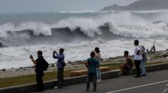
The storm is whipping up waves that are already several meters high along the coastline. Fishing boats have been recalled to harbors, tightly lashed together to prevent them from crashing into concrete piers. The government has deployed military personnel to assist with sandbagging and to ensure that anyone living in low-lying areas moves to designated emergency shelters before the worst of the rain hits on Friday night.
The Interconnected Threat Facing Japan and China
Typhoon Bavi won't stop at Taiwan. The current meteorological models indicate that after brushing past Taiwan's northern tip, the storm will sweep through Japan’s remote southwestern islands before barreling directly into mainland China over the weekend.
This presents a massive logistical nightmare for regional disaster management teams. China is already dealing with a week of severe summer storms that have left soil conditions highly saturated and rivers running dangerously high. Adding the massive rainfall from a mature typhoon could push local river systems past their breaking points.
We need to look at how these countries coordinate. While each nation has its own independent meteorological agency, the shared threat of these superstorms requires intense, real-time data sharing. When a storm leaves the Philippines, moves past Taiwan, hits Japan, and terminates in China, the entire region relies on the accuracy of upstream data. If one link in the chain fails to predict the rainfall volume accurately, thousands of lives are put at risk downstream.
What Most Emergency Plans Get Wrong About Severe Weather
Most corporate and municipal emergency checklists focus on the wrong things. They tell you to secure loose outdoor objects and buy flashlights. Those are fine for basic storms. But a monster like Typhoon Bavi requires a completely different mindset.
The biggest mistake is assuming you can outwait the storm in an area prone to flooding or landslides. Mudslides don't give you a five-minute warning. They happen instantly. If local authorities issue a voluntary evacuation order for your hillside or coastal zone, you need to leave immediately. Waiting until the order becomes mandatory usually means the roads are already flooded or blocked by fallen trees, trapping you in the danger zone.
Another major blind spot is secondary infrastructure failure. Everyone prepares for power outages. Fewer people prepare for the total loss of running water or cellular network failure. When cell towers lose power or get knocked down by high winds, your smartphone becomes useless for emergency alerts. Having a dedicated, battery-operated weather radio is one of those old-school solutions that actually works when modern tech fails completely.
Actionable Next Steps For Coastal and High-Risk Residents
If you're living anywhere along the projected path of Typhoon Bavi or any future major storm system, you need to take specific steps right now. Don't wait for the skies to turn gray.
- Map out two distinct evacuation routes. Don't rely on your primary road. Landslides and flash floods frequently block main highways. Know the secondary backroads that lead to higher ground.
- Secure critical documents in a waterproof, portable container. Passports, deeds, insurance policies, and medical records should be packed together so you can grab them in less than sixty seconds if you're told to run.
- Establish a non-digital family communication plan. Decide on a specific meeting point outside your immediate neighborhood. Pick an out-of-town relative as a central contact person everyone can call or text to report their safety if local networks are congested.
- Check your emergency water supply immediately. Assume water treatment plants will go offline. You need at least three gallons of water per person to cover basic hydration and sanitation for a few days.
The window for preparation closes the moment the first heavy rain bands arrive. Watch the local updates, heed the evacuation warnings, and get to safe ground before the roads become impassable.